Monday, March 21, 2016

Sand Mining in Western Wisconsin: Data Collection

Introduction:

Once a research question has been proposed the next concrete step is to collect data. To understand the impacts that frac sand mining has on surrounding areas it was required to find and acquire datasets from numerous government sources. This data then had to be put through a sting of tools (see “Python Scripting Two” below) to normalize and prepare for use. All the data sets were acquired for use in Trempealeau County Wisconsin.


Methods:
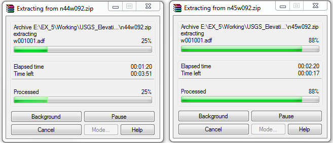
Figure one. Information databases typically come in a compressed file format (zipped). This saves memory space and make for quicker downloads. The above image shows and extraction program in the process of decompressing zipped files.
The first objective of this exercise was to actually find and download data for Trempealeau County. There were four different government websites visited for six datasets (Figure five). One had to find each particular dataset by selecting different parameters before downloading. All the datasets were initially downloaded as zip files and required extraction before use (Figure one).
Figure two. Naming folders appropriately helps a researcher to recall where information is held.
 The compressed files were extracted into labeled folders in a permanent drive. Folder names reflect the source and subject of each dataset. This helps to keep files from being lost or misinterpreted.

    This project focuses on the early steps of manipulating data. This involved the fine process of changing file types, reorganization, examining feature attribute tables. Ultimately this led to making relationships among individual feature classes with the use primary and foreign keys.
Figure three. Results of clipping a rail network via county borders. Rails that exist within county in red. Rails in green are not needed for the area of interest so removing them is a good practice in data management. 
Data management is a cornerstone for any well-organized project. Having files that cover more than the necessary ground is a waste of space, clipping features removes information and preserves what is important for the project. See figure three for an example. A somewhat contradictive issue in regards to file size also became apparent when downloading data for this project. The digital elevation model (DEM) downloaded from the USGS did not cover the entirety of the county. There was one small section on the county’s south point that was omitted meaning that a second DEM needed to be downloaded (See figure four). An image mosaic needed to be completed between these two raster files. The output file was in unsigned 16 bit format and only had one radiometric band which is not an issue as this file only had one band to start out with.  
Figure four.  Digital elevation data comes as a raster image that covers a large area. In the case of Trempealeau County two images (blue tint and red tint) are needed for full coverage. 
Once all the information was downloaded I went on a search through each datasets respective metadata file to assess their reliability. Observe figure five for results.
Figure five. Metadata accuracy information for downloaded datasets.
Conclusions:

All data has limitations and knowing what they are is key to its accurate representation. The datasets that were downloaded range in spatial and temporal accuracy and are a blend between vector and raster type files. For a large scale map that depicts a village or town sized area these could lead to issues in regards to accurate representation. The spatial resolution is far too course and changes over time are far more pronounced meaning the datasets that haven’t been updated lately would be a key concern. This project focusses on Trempealeau County, an area with a relatively large scale, meaning that the precision is not as imperative.

Friday, March 18, 2016

Python Scripting Two: Batch Processing

   As mentioned in the last blog, Python scripting for ArcGis can be used to automate tedious and repetitive tasks. In the below example (figure one) a “for loop” was used to name, locate, project, extract (the vector equivalent of this tool would be “clip”) and copy to a different geodatabase.
Figure one. Python coding used to batch process a raster dataset. 

 While creating this code I experienced several setbacks and many error messages, most of which were due to my own inexperience with coding. The data set I was working with only totaled three raster files meaning that it would have been much faster for me to have run each raster individually.  But it is the principle of the matter which is important and making a batch data processing code is immensely important for a dataset that totals many more files than the one used for this exercise.

Results:

Figure two. Elevation data raster for Trempealeau County WI. 
Figure three. Land use in Trempealeau County (too many specific types of land use to fit in legend, see figure four for simplified labels). 
Figure four. Generalized land use map for Trempealeau County.


Tuesday, March 15, 2016

Python Scripting One: An Introduciton to Coding for ArcMap

As a basis for future GIS work having a basic understanding of the coding language called Python as it relates to ArcGIS is indispensable.  This post is collective of some introductory exercises that were completed for lab. Python is a coding language used in ArcGIS as a way to complete tasks which would otherwise be very difficult or time consuming if using the more conventional functions of ArcGIS programs. While Python scripting has a much steeper learning curve relative to using GIS tools individually and using a model builder, it is not limited in the same ways. For example, one can create a script to automate complex yet tedious and repetitive tasks. 

Figure one: Collective demos for python scripting. 
There were three different sections for the introductory Python scripting material.  The first section was simply running ESRI ArcMap tools with a script. One will notice this as the green, pound signed block located roughly in the middle of the figure one (it was pound signed so as to speed up diagnostics for later operations). A buffer tool was run shortly before a clip tool.
The second part is listed above the clip and buffer tools is where variables are being defined so the tools can be used for multiple datasets without being rewritten for each time. One only needs to redefine the set parameters for each dataset making it fairly easy to adapt from one place to another.

The third and final section of this short introduction to Python was coding to automatically fetch and display file metadata such as projection. A secondary line of code was used to list raster files in a geodatabase and display the file name and spatial reference. In figure one this is expressed below the green buffer and clip tool code. 

Friday, February 26, 2016

Sand Mining in Western Wisconsin: Overview

Goal and background: 
This post is intended to supply background information on the topic of frac sand mining in Wisconsin. Later in the semester this information will be greatly expanded upon through projects utilising numerous GIS tools; these will entail everything from mapping locations of Wisconsin mines to measuring the use and wear on local roads by the sand mining industry.
sand grain.JPG
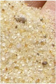
Figure 1. Sand grain size, shape, and coloring. (Wisconsin Geological and Natural History Survey, "Frac sand in Wisconsin", 2012)
Frac sand mining is the process of extracting sand of a specific grain size and composition from the earth. Wisconsin is host to numerous deposits of well sorted sand. Sand from this region is high in silica content and has a round shape and uniform grain size. These characteristics make this type of sand ideal for its use in oil and gas extraction; the mining technique is called “hydrofracking.”
Hydrofracking is where a water and a chemical mixture are used to crack, or fracture, layers of hard rocks, such as granite, to reach previously untapped resources of oil and natural gas. The sand is inserted to hold open the fractures to allow the extraction of oil and gas (Wisconsin Geological and Natural History Survey, "Frac sand in Wisconsin", 2012).
Many people confuse the two processes; the sand is extracted via traditional mining processes then inserted along with the water and chemicals to mine the oil and gas (Chase, Burchem, Golden, "12 Sandy GIFs: An animated guide to Wisconsin's frac sand rush", 2015).
Frac sand mining follows many of the same conventions as other non-ferrous mining operations. The mines are required to get permits, take appropriate responsibilities to prevent the release of waste materials and participate in a reclamation process for each mine (Wisconsin Department of Natural Resources, "Registering nonmetallic mineral deposits", 2015).


Location of Frac Sand Mines:
DNRMAP.JPG
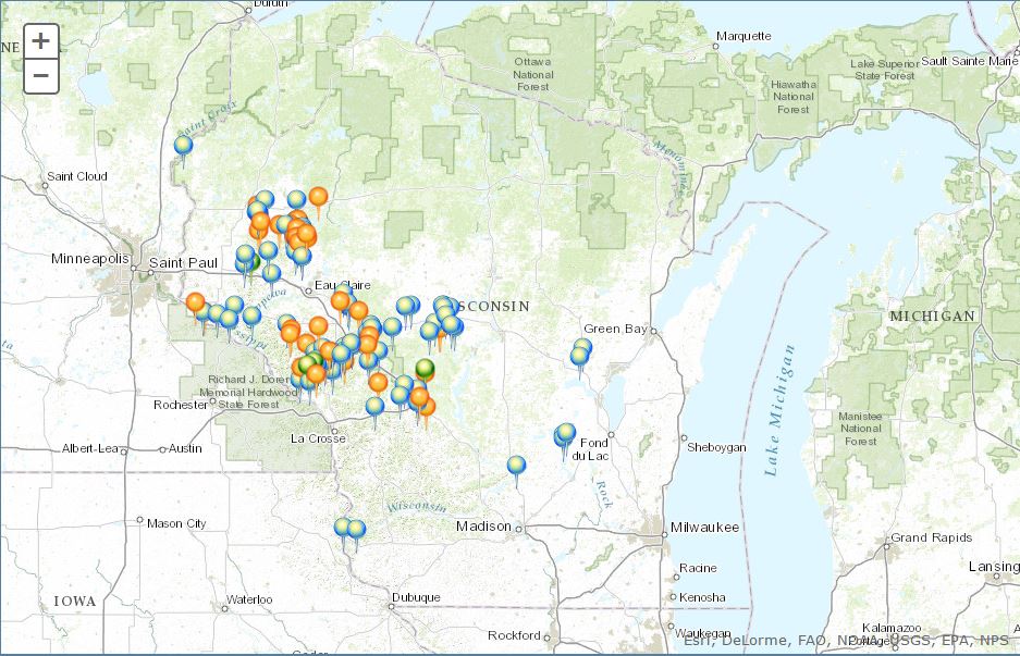
Figure 2. Wisconsin DNR map showing locations of frac sand mines. (Wisconsin Department of Natural Resources, "Locations of industrial sand mines and processing plants in Wisconsin", 2016)

Frac sand mining is located in middle to western Wisconsin. Figure 2 is a map displayed on the Wisconsin’s DNR website showing the locations of all active (Blue pins) and inactive (orange pins) mine sites. The Green pins show the locations of mines currently going under the process of reclamation. one can notice that the mine locations are clustered in the west-central portion of the state, this a literal reflection of the location for the most easily accessible sand of the correct grain shape and size. River and ocean/lake shore sands are less coveted due to the angular shape of the grains which makes them less useful for hydrofracking (Wisconsin Department of Natural Resources, "Registering nonmetallic mineral deposits", 2015).

Issues:
There are several issues regarding frac sand mining in Wisconsin. Some of these include regulation, mine reclamation, control of hazardous substances, maintaining safe drinking water in the surrounding area, monitoring particulates in the air, protecting abandoned boreholes (Wisconsin Department of Natural Resources, "Industrial sand mining", 2016). In addition, those located close to the mines deal with noise, pollution, damage to agricultural land, and health issues that the mining brings about (Schuessler, "Wisconsin locals fear dust from mines for fracking sand even as boom wanes", 2015). Many of these parties protest the inadequate laws and insufficient enforcement of laws that do exist (Wisconsin League of Conservation Voters, "Frac Sand Mining").
Lastly, frac sand mining places strain on infrastructure such as roads and rail lines leading to disputes on repairs. This can cause tension between the sand companies and local governments (Chase, "As rail moves frac sand across Wisconsin landscape, new conflicts emerge", 2014) (Christenson, "Pepin County settles dispute over frac sand road-use agreement", 2015).
Sources
Chase, T. (2014, July 13). As rail moves frac sand across Wisconsin landscape, new conflicts emerge. Retrieved February 26, 2016, from http://wisconsinwatch.org/2014/07/as-rail-moves-frac-sand-across-wisconsin-landscape-new-conflicts-emerge/
Chase, T., Berchem, J., & Golden, K. (2015, April 06). 12 Sandy GIFs: An animated guide to Wisconsin's frac sand rush. Retrieved February 26, 2016, from http://wisconsinwatch.org/2015/04/12-sandy-gifs-an-animated-guide-to-wisconsins-frac-sand-rush/
Christenson, J. (2015, August 17). Pepin County settles dispute over frac sand road-use agreement. Retrieved February 26, 2016, from http://www.winonadailynews.com/news/local/govt-and-politics/pepin-county-settles-dispute-over-frac-sand-road-use-agreement/article_1b5d40e5-6d80-584e-897c-359b09cebdda.html
Schuessler, R. (2015, November 6). Wisconsin locals fear dust from mines for fracking sand even as boom wanes. Retrieved February 26, 2016, from http://america.aljazeera.com/articles/2015/11/6/wisconsin-locals-fear-frac-sand-mining.html
Wisconsin Department of Natural Resources. (2015, April 15). Registering nonmetallic mineral deposits FAQ. Retrieved February 26, 2016, from http://dnr.wi.gov/topic/Mines/Deposit.html
Wisconsin Department of Natural Resources. (2016, January 7). Locations of industrial sand mines and processing plants in Wisconsin. Retrieved February 26, 2016, from http://dnr.wi.gov/topic/Mines/ISMMap.html
Wisconsin Department of Natural Resources. (2016, July 06). Industrial sand mining. Retrieved February 26, 2016, from http://dnr.wi.gov/topic/mines/sand.html  
Wisconsin Geological and Natural History Survey. (2012). Frac sand in Wisconsin. Retrieved February 26, 2016, from http://wcwrpc.org/frac-sand-factsheet.pdf
Wisconsin League of Conservation Voters. (n.d.). Frac Sand Mining. Retrieved February 26, 2016, from http://conservationvoters.org/issues/frac-sand-mining/